An avalanche forecast is key to understanding the potential dangers you may face when venturing out into the backcountry in the winter. It should be the foundation for planning your day out—whether you ski, snowboard, snowshoe or hike in snow-covered mountains. The forecast will provide you with a lot of information, but it's only a starting point for safe backcountry travel, which also requires preparation, experience and education. You control your own risk by deciding where and when you go, and how you travel. Remember, your decisions are what will keep you safe!
In this article, we'll explain what an avalanche forecast is, where to find it, what information it contains and the basics of understanding it.
Remember: Safety is your responsibility. No internet article or video can replace proper instruction and experience; this article is intended solely as supplemental information. Be sure you're practiced in proper techniques and safety requirements before you engage in any outdoors activity.
What Is an Avalanche Forecast?
An avalanche forecast tells you about avalanche danger and snowpack conditions for a given mountainous region over a specific period of time. Forecasts are issued by a network of backcountry avalanche centers across the U.S. and Canada.
Here are things to know about the forecasts:
- They're large-scale descriptions of the day's avalanche danger in broad, general terms and not specific to particular slopes.
- Forecasts change daily, much like a weather forecast.
- Always check to make sure you have the forecast issued for the day you're going out; some advisories expire within a certain time period.
- Not all avalanche centers issue daily forecasts, though larger centers generally do.
- These forecasts apply to avalanche terrain—generally slopes steeper than 35 degrees—not ski resorts or highways where avalanche control takes place.
In addition to avalanche forecasts, centers may issue bulletins, watches and warnings.
- Avalanche warning: High avalanche danger is expected within 24 hours of the forecast; travel in avalanche terrain isn't recommended or should be avoided entirely.
- Avalanche watch: Very dangerous avalanche conditions are expected in the next 24 to 48 hours.
- Special bulletin: Dangerous conditions exist but conditions don't meet the level necessary for an avalanche warning.
Where Do I Find an Avalanche Forecast?

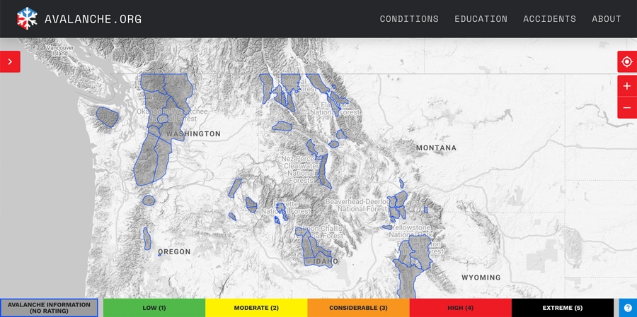
To find an avalanche forecast for your region, start with the U.S. avalanche map, a website operated by the American Avalanche Association and the National Avalanche Center. Find your region on the map and click on "Get the Forecast" for more information.
You can also navigate directly to the website of the avalanche center in your region. Use this directory of avalanche centers to find your local center in the U.S. Forecasts for Canada can be found at avalanche.ca.
Check for published times: Local avalanche centers publish daily forecasts at different times. For example, the Northwest Avalanche Center publishes its forecast in the evening for the next day (e.g., Tuesday's forecast is published Monday night), while the Colorado Avalanche Information Center says it "issues avalanche forecasts each day by 4:30pm."
What Info Will I Find in a Forecast?
The forecast provides tiered information for backcountry recreationists. It ranges from simple information such as a five-level danger rating with associated colors, numbers and icons for those with little to no avalanche education to more detailed information describing avalanche characteristics for those with some formal training. Depending on your region, there will be differences in how and what information is displayed. Still, a lot of the information will be similar across forecasts (though packaged in different ways). We'll cover those similarities below.
Danger Rating
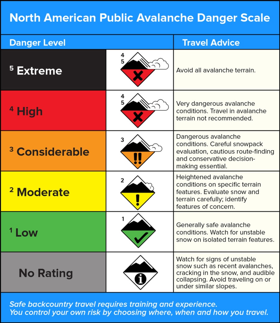
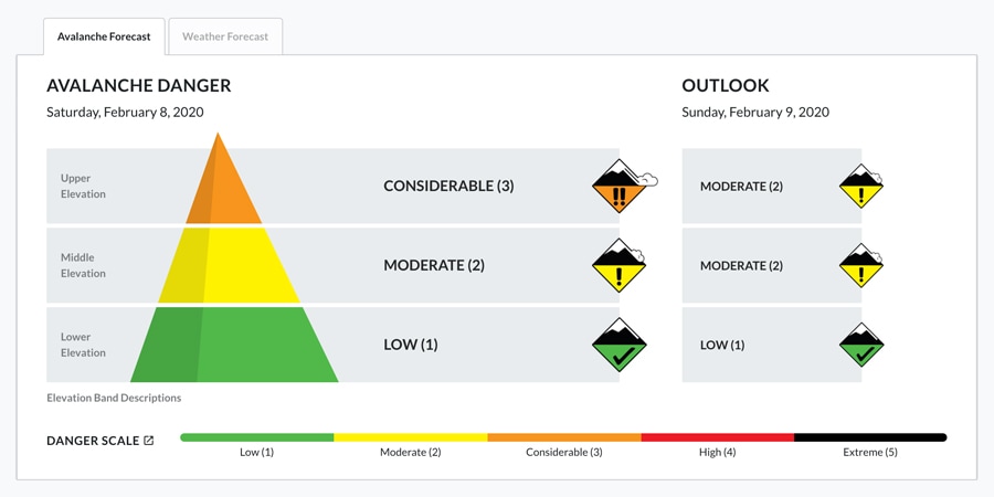
One of the first things you'll see is the current avalanche danger for the region. You'll find a map color coded on a five-level danger rating system. The North American Avalanche Danger Scale is a standardized tool used to communicate avalanche hazards to recreational users. Each number (1-5) and a color (green, yellow, orange, red and black) describes a specific level of avalanche danger along with travel advice. The definitions for the danger level are consistent whether you're in Oregon or Wyoming.

The ratings tell you how dangerous it is:
- Low: Generally safe avalanche conditions. In other words, you're probably fine but keep your eyes open. There's a chance of avalanches.
- Moderate: Heightened avalanche conditions on specific terrain features. In other words, there are places in the terrain where you can trigger an avalanche. Figure out where you are and identify those features and avoid those features.
- Considerable: Dangerous avalanche conditions. In other words, you can trigger avalanches on these days. You need to be conservative. You need to be cautious. You can still go out and have a good day, but you really need to dial it back and pay attention to where you're traveling.
- High: Very dangerous avalanche conditions. In other words, do not go anywhere near avalanche terrain, which is anywhere an avalanche can start, run or stop.
- Extreme: Avoid avalanche terrain. In other words, stay home.
Sometimes you will find danger ratings for different elevations, such as below treeline, near treeline or above treeline.
Bottom Line/Summary
In most forecasts, you'll find a summary paragraph or "the bottom line" that provides a few sentences summarizing what you can expect for that day. This paragraph is typically prominent.

Travel Advice for the Backcountry
One of the most important things you, as a backcountry traveler, should focus on is the travel advice, which tells you how to behave when you're out. You may find travel advice scattered throughout or in a separate paragraph. This is a forecaster's opinion about what to look for and what terrain to avoid. The forecast may tell you, for example, "Avoid lee slopes steeper than 35 degrees where you find wind-deposited snow" or "avoid slopes >35 degrees as the chances of triggering a storm slab will be likely."
Also pay attention to the travel advice associated with the danger rating. The first few words of the rating should leave a reasonable impression on you about the avalanche conditions and how you should act. For example, a moderate (yellow) rating explicitly tells you to "evaluate snow and terrain carefully; identify features of concern," whereas the considerable (orange) rating tells you "careful snowpack evaluation, cautious route-finding and conservative decision-making essentials."
For more on the danger scale, watch this tutorial by the National Avalanche Center.
Avalanche Problems
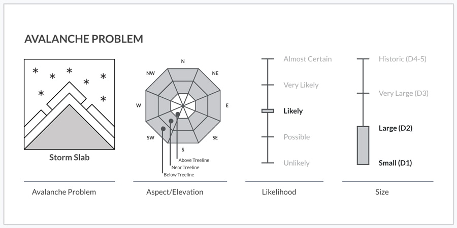
Deeper into the forecast you'll find an in-depth look at the nuances of snowpack and avalanche conditions that you're likely to encounter that day. This information is best understood by users who have had at least some avalanche education. Forecasters will typically list one to three "avalanche problems," which describe specific characteristics of a potential slide. In the U.S., forecasters use nine distinct "types" or "problems" (e.g., wet loose or dry loose or slabs formed by wind and so on). Each type typically comes with different travel advice.

In the forecast, you'll find a discussion about:
- The avalanche type or characteristics
- Where you'll find that problem (elevation and aspect)
- How likely you are to trigger it ("certain," "likely" or "unlikely")
- How big the potential avalanche will be (small, large, very large or historic)
For a more in-depth explanation of avalanche problems, read this explainer by the National Avalanche Center.
Mountain Weather Forecast
Mountain weather forecasts can give you an idea of the weather you can expect. Some will be simple; some will be complex. Because avalanche safety is so dependent on the weather forecast, make sure you also check the weather.
What to Do with Forecast Information
Once you've accessed the forecast and read it, the next step is to figure out how to use it. The forecast will tell you what terrain and slopes you should avoid. It will tell you where you should not go for that day (everything else is considered fair game).
A great way to learn is to read the forecast frequently throughout the season, not just when you need it. Track the season's conditions; it will help you pick up on the terms used by forecasters and figure them out before you go out into the mountains.
Armed with this information, keep your eyes open as you travel. Pay attention to the snow and make sure conditions align with what you expect. If what you see as you travel doesn't align with what you expected, it's time to dial back and find safer terrain. By getting formal avalanche training, you can learn how to take the forecast into account as you plan for your day's travel.


