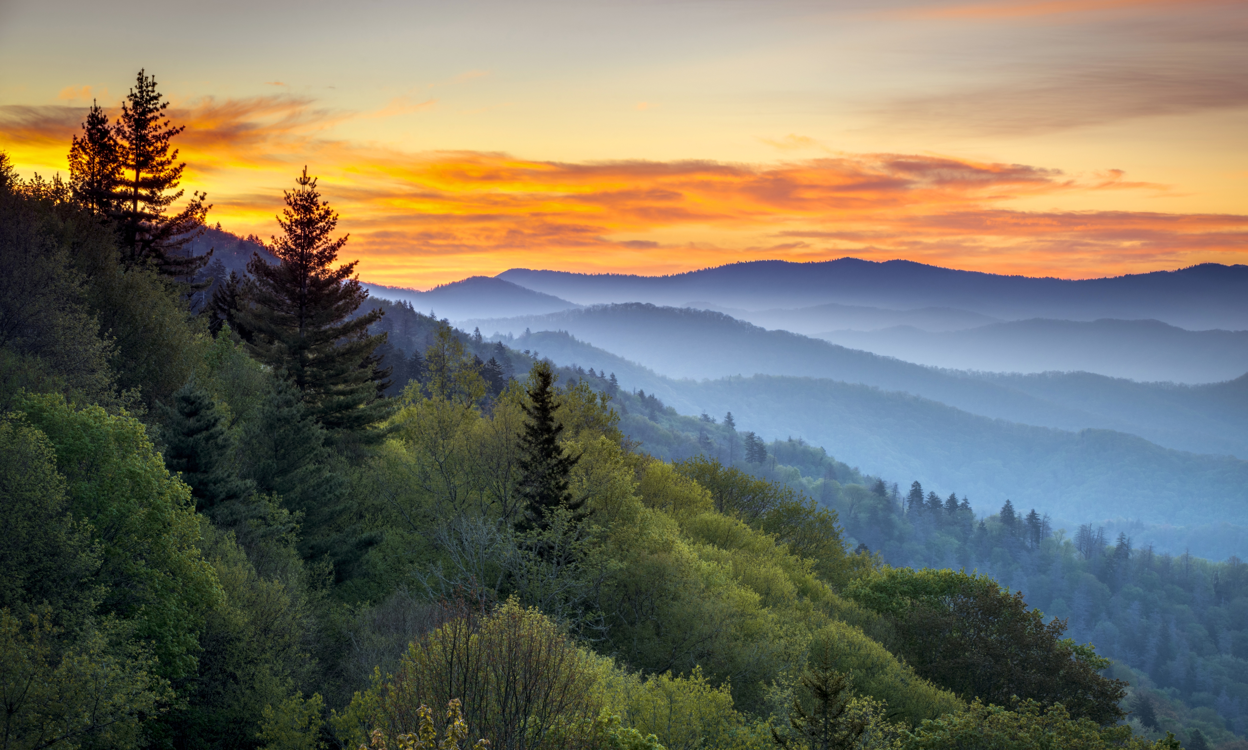
Encompassing more than a half a million acres, Great Smoky Mountains National Park is one of the largest natural areas in the eastern U.S. Visited by more than 9 million people each year, it’s our most heavily used national park, and not without good reason.
Straddling the border between Tennessee and North Carolina, this Appalachian Mountains icon is home to nearly 100,000 different species of plants and animals.
The park’s 1,500-plus types of flowering plants are more than any other national park, so it’s an ideal place to see wildflowers. And fall colors can be spectacular if you time your visit carefully.
Waterfalls are popular destinations year-round, especially in early spring or after an extended period of rain. Those who enjoy fishing will find one of the last wild trout habitats in the eastern United States. History buffs will appreciate the historic buildings and artifacts scattered throughout the park, tangible reminders of the area’s early settlers.
While many opt to experience the park through visitor centers, viewpoints and car windshields, you’ll get a more intimate — and likely more rewarding — experience of the park through activities like camping, bicycling, hiking and backpacking.
Since your options for exploring the Smokies are vast, we talked to our camp/climb experts in the Knoxville REI store to get a few of their insider suggestions for exploring the park.
Camping in the Smokies
There are 10 car-accessible campgrounds, offering more than 900 total campsites. Fees range from $17 to $30 a night, and online reservations are available through the national recreation.gov website. Four of the campgrounds accept reservations, while the other six are first-come, first-served.
Here are a few of the campgrounds our Knoxville REI experts suggest:
Cataloochee Campground (27 sites, reservation-only): Even though it’s a popular destination, the small number of sites means you won’t feel crowded. Surrounded by 6,000-foot peaks, it’s on the North Carolina side of the park near its eastern boundary.
Cataloochee Valley is where a variety of historic structures have been preserved. This is the best place in the park to see frame buildings from the late 19th and early 20th centuries. The Boogerman Trail here passes through old homesteads and old growth trees. Site of a successful wildlife reintroduction project in 2001, the valley is also home to the park’s biggest elk herd. Early morning and evening hours here give you the best chance to view these animals in the park.
Reached via a narrow, winding gravel road, the campground is open from early April through the end of October.
Elkmont Campground (220 sites, reservable): This is the largest and perhaps most centrally located campground in the park. If you can cope with crowds, you might find Elkmont intriguing because of its synchronous fireflies. This unique species that flashes in unison can be seen every year in late May or early June. The only ways to access the park’s special viewing area during the peak season are to stay at Elkmont Campground or to take a shuttle bus from the Sugarlands Visitor Center.
The campground is open from the middle of March through the end of November, and it offers amenities like electrical hookups and a dump station for RVs.
Abrams Creek Campground (16 sites, non-reservable): This is an excellent off-the-beaten path option on the Tennessee side of the park, near its western boundary. The campground is a great base for day hikes, including a number of loop-trail options. Low hiker traffic on these trails makes them a pleasant alternative, even if the final destination is the ultra-popular Abrams Falls.
The campground is open from late May through the middle of October on a first-come, first-served basis.
Deep Creek Campground (92 sites, non-reservable): This midsize campground is on the North Carolina side of the park, near its southern boundary. The Deep Creek area offers a range of day hikes, including the 2.4-mile Three Waterfalls Loop Trail. The area also has a trail section that’s open to bike riding, one of the few places in the park where this is possible.
The campground is open from early April through the end of October on a first-come, first-served basis.
Hiking and Backpacking in the Smokies
For hikers and backpackers, the park offers more than 800 miles of trails, including a section of the Appalachian Trail that runs the length of the park.
Overall, park trails are both well maintained and well signed, making navigation relatively uncomplicated. Be aware, though, that the park has a number of ancient way-trails called “manways” that can lead you astray. They can be easily avoided if you stick to the obvious main trails, especially when approaching switchbacks.
Backcountry Permits: Available for $4 per night (a maximum of $20 per trip), these can be reserved online up to 30 days in advance of your visit. Check the backcountry permits page for availability of individual shelters and backcountry camps for a given date.
Trip planning assistance is also available through the Backcountry Office by calling 865-436-1297 (8 a.m. to 5 p.m. EST, seven days a week).
Appalachian Trail (AT) Thru Hiker Backcountry Permits: Available from the park’s backcountry permits page, this is a flat rate of $20 per trip and the permit is exclusively for those hiking the AT trail through the park. Because shelter campsites are set aside for thru hikers, you don’t need to reserve shelters as long as you meet all of the criteria required for an AT permit.
Great Smoky Mountains Backpacking Packing List: We’ve put together a comprehensive checklist for backpacking in Great Smoky Mountains National Park, including hiking essentials, clothing and personal gear.
For more information on planning day hikes and backpacking trips, visit the Great Smoky Mountains National Park hiking page and the backcountry things to know page.
Following are a few less-traveled gems to get you started. Many of the routes can be varied using loop-trail options or extended to create a longer day hike or backpack trip.
Recommended Hikes
Abrams Falls Day Hike (moderate; 10 miles round-trip): Abrams Falls is extremely popular, but almost everyone hikes to it from the other direction, starting at Cades Cove. This alternate route is twice as far as the route from Cades Cove, but you’ll see far fewer people. Park at Abrams Creek ranger station and walk the road through the campground to Cooper Road trail. At the junction there, turn onto Little Bottoms trail and hike to the Abrams Falls Trail. From here, it’s a final 2-mile stretch to the falls. Because of dangerous undercurrents, the park service warns people not to swim at the base of the falls, so enjoy them from another vantage point.
Andrews Bald Day Hike (easy; 3.6 miles round-trip): A “bald” is a high-elevation meadow found in the Southern Appalachian Mountains. Balds are also great places to enjoy some expansive views. Drawn to the highest point in the park, most tourists park in the Clingmans Dome lot and walk to the observation tower there. Hikers have a better option: The Forney Ridge Trail starts from the same parking lot, yet lets you leave the tower crowds far behind. Andrews Bald offers dramatic views and, in late spring and early summer, a colorful show of rhododendron and azalea blooms.
Ramsey Cascades Day Hike (moderate to strenuous; 8 miles round-trip): A really beautiful hike to the tallest waterfall in the park, this will be less crowded than other waterfall trails, but can still be busy during the peak summer season. You’ll separate yourself from less ambitious hikers, though, because Ramsey Cascades Trail gains more than 2,000 feet over its 4-mile course.
Boogerman Day Hike (moderate; 7.5-mile loop trip): This hike passes through the lands of early settler Robert “Boogerman” Parker, who resisted selling his timber to lumber companies. The result is a route that lets you enjoy some of the tallest trees in the park, old stone walls and other remnants of his old homestead. The route has numerous footbridges and other stream crossings that can be difficult in high water, as well as frequent horse traffic in some sections of the trail. You also have a chance to encounter elk here.
Park at a lot just past the Cataloochee Campground and try to arrive early on weekends because the lot fills up fast. Head out from the Caldwell Fork Trailhead and, in less than a mile, reach the Boogerman Trail junction. Here you decide which way to do the loop: Turn onto the trail here or hike another few miles to the upper junction with the Boogerman Trail. Whichever way you go, wayfinding can be tricky, so investigate stream crossings carefully to be sure they’re truly on the main trail.
Maddron Bald Backpack (moderate; 18-mile loop trip): This hike starts and ends in Cosby Campground in the northeastern corner of the park, on the Tennessee side. You begin at an elevation of 2,459 feet and follow the Gabe’s Mountain Trail to the Maddron Bald Trail and finish by taking the Snake Den Ridge Trail back to Cosby Campground. The route has two backcountry campsites that you need to reserve.
The route also takes you to the Albright Grove Loop Trail, a 0.7-mile side trip through beautiful old growth forest. Other highlights include Hen Wallow Falls, which you pass on the first day, and the 5,212-foot summit of Maddron Bald, which you reach early on the last day of your three-day trip.
Mount Sterling Backpack (moderate to strenuous; 22.5-mile loop trip): This adventurous three-day hike starts in Big Creek Campground in the northeast corner of the park, near the border between North Carolina and Tennessee. The route has two backcountry campsites that you need to reserve. It follows Big Creek Trail to the Gunter Fork Trail to the Balsam Mountain Trail to the Mount Sterling Ridge Trail and finishes by heading down the Baxter Creek Trail. You can cut 6 miles off by taking the Swallow Fork Trail instead of the Gunter Fork and Balsam Mountain Trails, or you can add mileage using a variety of other trails in the area.
Regardless of which route you pick, you’ll be doing a lot of climbing because Big Creek is at an elevation of 1,700 feet and Mount Sterling is 5,842 feet high. Any of your route choices will let you enjoy Big Creek’s many great swimming holes in the beginning and sleep atop Mount Sterling on your last night.
Gregory Bald Backpack (moderate; 17-mile loop trip): This moderate three-day hike starts at Twentymile Ranger Station in the southwest corner of the park, near the border between North Carolina and Tennessee. This 17-mile route starts at 1,325 feet and climbs as high as 4,984 feet, passing through a region that sees a lot less visitors than other areas in the park. You need to reserve two backcountry campsites, but will have some alternatives if either of those is booked.
The route follows the Wolf Ridge Trail to the Gregory Bald Trail to the Long Hungry Ridge Trail to the Twentymile Loop Trail, where you ultimately reach a junction with the Wolf Ridge Trail you hiked in on. Gregory Bald, which you can visit at the end of the first day or the start of the second day, offers dramatic views. The bald can also have intense bear activity in late summer when the berries are ripe.
Biking in the Smokies
Most roads in Great Smoky Mountains National Park are open to cycling, but steep terrain, narrow roadbeds, and heavy car traffic make most of them ill suited to safe and enjoyable riding. The park has no mountain bike trails, although two short walking paths and one old roadbed section of a hiking trail are open to cyclists. Mountain bikers can head to adjoining National Forest lands, where many miles of trails await.
The best cycling option in the park is at Cades Cove, where you can ride on an 11-mile loop road that’s closed to motor vehicles until 10 a.m. every Saturday and Wednesday morning from early May until late September. You can rent a bike at the Cades Cove Campground Store.
For more information, visit the Great Smoky Mountains National Park Bicycling page.
Other Activities in the Smokies
Fishing: Fishing is permitted year-round in the park’s nearly 3,000 miles of streams. Brook, rainbow and brown trout thrive here, along with smallmouth bass and rock bass. Available from nearby towns, a valid fishing license or permit from either Tennessee or North Carolina is required.
Horseback Riding: There are four riding stables throughout the park where you can arrange to take guided horseback rides from mid-March through late November.
Kayaking / Canoeing: Flatwater paddling is available on Fontana Lake, which lies along the southern, North Carolina border of the park. Several private companies offer canoes and kayaks for rent here.
Snowsports: Because the park is open year-round, you can enjoy some snowy solitude by planning a well-equipped winter trip. That kind of adventure often entails hiking at lower elevations, then switching to cross-country skis or snowshoes higher up.
Tips for Visiting the Smokies
Getting to Great Smoky Mountains National Park
Located in the southeastern part of the U.S., the park straddles the border between North Carolina and Tennessee. See the Great Smoky Mountains Directions & Transportation page for information about traveling to the area. The nearest REI stores to the park are in Knoxville, TN, and Asheville, NC.
Great Smoky Mountains Fees and Passes
Unlike other national parks, Great Smoky Mountains National Park charges no entrance fee, though the park will charge a fee if you choose to stay in a car campground. For your backpacking trip, you’ll need a backcountry permit.
If you go with a guided tour, like REI Adventures, fees and passes are typically included in the cost of the trip.
Weather, Road Conditions and Visiting Tips for the Smokies
Elevations in the park range from 800 feet to 6,643 feet, a topographic difference that can drastically affect local weather. Temperatures can vary by 10-20 degrees Fahrenheit between the base of a mountain and its summit. Also, clear skies in the lowlands do not guarantee equally pleasant weather at higher elevations.
Rainfall averages 55 inches per year down in the valleys, rising to 85 inches per year at the top of Clingmans Dome, the highest point in the park. Temperatures range from an average high of 88 degrees Fahrenheit in the lowlands in mid-summer down to an average low of 18 degrees Fahrenheit in the high country in winter. Good planning and weather-wise packing are critical for an enjoyable trip.
Weather and road info: Call 865-436-1200 for weather and road-closure details. For forecasts and more details about park weather, visit the Great Smoky Mountains Weather page.
Timing your visit: The park is open year-round, although individual roads and facilities have seasonal closures A March-through-November backpacking season offers you a broad range of hiking possibilities. It’s also possible to visit in winter, when lowland trails can offer hike-in access to snowshoeing and cross-country ski touring up higher.
Strategies to avoid crowds: Consider a trip outside of the two peak seasons: mid-summer (June 15-August 15) and the entire month of October. Weekends in October are especially crowded, and you should expect traffic delays. Hit the trail early in the day, before 10 a.m., to avoid large numbers of day hikers. Visit an off-the-beaten-path destination like Cosby, Fontana Lake or Greenbrier Cove. Abrams Creek, which has many loop-trail options, is another less frequently used area.
Great Smoky Mountains Guidebooks and Maps
The park service website and its Smokies Trip Planner are excellent resources. A number of other websites also focus specifically on the park. Books and maps can be found at nearby REI stores in Knoxville, TN, and Asheville, NC.
Another great resource for guidebooks is the Great Smoky Mountains Association (GSMA), which operates bookstores in the park’s four visitor centers, as well as an online site: GSMA store.
Many excellent guidebooks cover the park, but one of the most comprehensive ones is Hiking Trails of the Great Smokies, by Kenneth Wise.
Lodging
The lone in-park facility is LeConte Lodge, a rustic lodge that can only be reached by hiking up 6,360-foot Mount LeConte. Several trails lead to the top, with distances ranging from 5 miles to more than 8 miles one way. The lodge is available by advance reservation only and it has a capacity of sixty guests in its 7 cabins and 3 multi-room lodges.
Traditional lodging options are available in the park’s surrounding communities, where you can also find many other amenities and services.
Food and Supplies in Great Smoky Mountains
Food and grocery services are limited, with one snack bar that serves hot food and a few other facilities that sell snacks, groceries and supplies within the park.
Special Concerns in the Smokies
Bears: Home to about 1,500 black bears, the park is one of the few places remaining in the eastern United States where black bears live in the wild. That’s why all backcountry users are required to hook their packs to bear cables overnight. Every backcountry site in the park should have one of these cables so you don’t need a bear canister within the park. Because some surrounding national forests require canisters, though, you should check with the forest you plan to enter if your trip takes you beyond the park borders.
Ticks and midges: While a lack of standing water means mosquitoes are less bothersome here, biting midges, biting gnats and ticks take up the slack. Look for repellents that are effective against all of these pests. It’s also wise to wear long pants to protect your lower legs, and gaiters to keep ticks out of socks and boots. Packing along a tick-removal tool is also a good idea.
Poison ivy: It’s here, but broad trails let you hike without bushwhacking. Nonetheless, the best way to avoid an uncomfortable rash is to learn how to identify its three-leaf form.
Snakes and wasps: Northern copperheads and timber rattlesnakes are around, but very few bites occur. Be cautious where you place hands and feet, especially around old buildings and stone fences. Yellowjacket wasps build nests in the ground and are aggressive when disturbed. Their stings cause local pain and swelling for most people. If you’re allergic, bring your epinephrine kit.
Heavy rain: Pack quality raingear, even in the summer, and be alert for flash floods after thunderstorms.
Water hazards: Over the years, a number of people have died from falling off waterfalls, trying to cross swollen creeks, or simply swimming in rivers. If you take reasonable precautions, though, you can enjoy the park’s watery wonders without incident.
Water quality: Lots of beavers and heavy human use make this a park where you don’t want to roll the dice on the quality of your backcountry water source. Pack a water treatment system, along with a backup option.
REI Knoxville Camp/Climb Sales Specialists Jared Jones, Bill Tribble Jr. and Gordon Mackenzie contributed to this guide.